Weather experts issue most threatening hurricane forecast yet
Weather experts issue most threatening hurricane forecast yet
By Jeff Berardelli
The 2020 Atlantic hurricane season is racking up storms at breakneck speed. To date, the season is about two weeks ahead of record pace and it's only one third of the way through. On Wednesday, the news became more concerning as the research team at Colorado State University (CSU) — the standard bearer for seasonal forecasts — released the most dire forecast in their 37-year history.
Labeling the 2020 hurricane season "extremely active," the team is now predicting 24 named storms, including 12 total hurricanes and 5 major hurricanes — each figure about double that of a normal season. If the forecast proves accurate, 2020 would be the second most active Atlantic hurricane season, behind only the record-shattering 2005 season which brought Hurricanes Katrina and Wilma.
Only 21 storm names are allotted each year because the letters Q, U, X, Y and Z are not used. As a result, if 24 tropical storms are indeed named, the National Hurricane Center will have to employ the Greek alphabet for overflow. This has only happened one time on record — in 2005 when the Atlantic experienced 28 named storms.
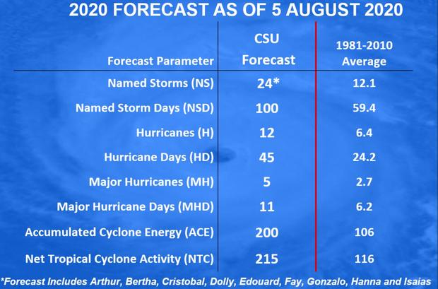
In addition, CSU is forecasting a 75% chance that the U.S. coast will be struck by a major hurricane — Category 3 or greater — during the 2020 season. This is significant because damage increases exponentially with wind speed. Category 3, 4 and 5 systems cause 85% of all hurricane damage.
Dr. Phil Klotzbach, the lead forecaster of the CSU team, tells CBS News that because the 2020 season is already on a record pace, and conditions remain ripe for activity, the forecast is not particularly far-fetched.
"Honestly, forecasting 15 additional named storms isn't that much of a stretch," he said. "The average season in the active era (from 1995-2019) had 12 additional named storms after August 5."
The last system, Hurricane Isaias, marked the fifth storm to make landfall this season. That's also about two weeks ahead of record pace.
The most obvious contributing factor for such an active season is water temperatures being near historic levels in the Tropical Atlantic, which can act like high-octane fuel to power hurricanes. In the image below, created by UNC-Charlotte graduate student Eric Webb, the darkest red-shaded areas are record warm.
CAM


Comments
Post a Comment